Climatology Database
The Climatology Database of the Charles Darwin Foundation allows you to visualize and download the historical daily climate records.
Despite its equatorial location, the Galapagos climate is not as tropical as it could be imagined. The island's topography, ocean currents and winds interact to modulate temperatures and define two distinct seasons.

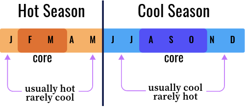
From January to May, the southeasterly winds weaken, diminishing the influence of cold waters coming from the Perú “Humboldt” Current and the equatorial upwelling. This is referred as the hot season, characterized by elevated sea and air temperatures, and convective rainfall. From June to December, the winds strengthen and cooler temperatures dominate.

These conditions generate a persisting layer of shallow clouds and continuous drizzle in the higher windward sides of the islands, and almost no rainfall in the rest of the archipelago.
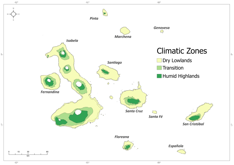
This rain shadow effect creates two broad terrestrial climatic zones: the humid highlands and dry lowlands, with an intervening transition zone.
Additional Resources
- Defeo, O., Castrejón, M., Ortega, L., Kuhn, A. M., Gutiérrez, N. L., & Castilla, J. C. (2013). Impacts of Climate Variability on Latin American Small-scale Fisheries. Ecology and Society, 18(4).
- Bush, M. B., P. A. Colinvaux, M. Steinitz-Kannan, J. T. Overpeck, J. Sachs, J. E. Cole, Collins, J. L. Conroy, and A. Restrepo. (2010) Forty years of paleoecology on the Galapagos. Galapagos Research 67: 55-64.
- Huttel, C. (1995) Vegetación en coladas de lava. ORSTOM y Fundación Charles Darwin, Quito, Ecuador.
- Robinson, G., and E. del Pino. (1985) El Niño in the Galápagos Islands: The 1982-1983 event. Noticias de Galapagos 44: 26-27.
- Sachs, J., S. N. Ladd, J. E. Cole, P. Goyes, D. Manzello, R. Martinez, C. Palacios, G. A. Vecchi, and L. Xie. (2010) Climate and oceanography of the Galápagos in the 21st century: expected changes and research needs. Galapagos Research 67: 50-51.
- Snell, H., & S. Rea. (1999) The 1997-1998 El Niño in Galápagos: Can 34 years of data estimate 120 years of pattern? Noticias de Galápagos No. 60: 11-20.
- Trueman, M. and d’Ozouville, N. (2010) Characterizing the Galapagos terrestrial climate in the face of climate change. Galapagos Research 67: 26-37.
- Wolff, M. (2010) Galapagos does not show recent warming but increased seasonality. Galapagos Research 67: 38-44.

Our Meteorological Stations
In 1965 the National Institute of Meteorology and Hydrology (INAMHI) installed several meteorological stations in different Galapagos Islands, managed by different institutions and people. However, the only one that has remained active is the one managed by the Charles Darwin Research Station, in Puerto Ayora, Santa Cruz Island.
Choose one among our meteorological stations to see its data:
Darwin Project
Dynamics of precipitation in transition:
The water source for the Galápagos Archipelago under climate change.
This network of 11 automatic weather stations (AWS) establishes a transect West-East (W-E) according to the locations of the islands on the archipelago, their altitude, and their exposition towards synoptic forcing.
We share standard high-temporal resolution data about precipitation, air temperature and humidity, solar radiation, and wind speed and direction.
In the coast stations of Santa Cruz turbulence is also offered. In the Cerro Crocker AWS, Santa Cruz island, we have some specialized equipment (radar and optical sensor) to compare precipitation variables.

You are welcome to download and use the information found in this page, acknowledging its source.
This page should be cited as follows:
"Galapagos Climatology Database", dataZone, Charles Darwin Foundation, https://datazone.darwinfoundation.org/en/climate. Accessed 23 February 2026.


